|
Land Use History and
Projections
- People
Jeff Kline: economics,
PNW
- Presentations
Modeling
Land Use Change
in the CLAMS Region
PDF - 1.6 mb |
|
 |
- Projecting Building Densities
and Land Use Change
Jeffrey D. Kline, Pacific Northwest Research Station, USDA
Forest Service
Private forestlands in the CLAMS region face increasing
pressures from growing human populations, resulting in increasing
urbanization and land use change. Urbanization and land
use change potentially can impact the ability of private
forests to produce future timber supplies. For example,
some researchers and forest policy analysts hypothesize
that urbanization and land use change tends to fragment
forested landscapes and reduce the degree to which private
forest owners manage and harvest timber. Urbanization and
land use change also potentially can impact ecological conditions
by altering the quality and availability of habitat for
terrestrial and aquatic species. This research describes
and projects the spatial distribution of humans throughout
the CLAMS region in past and future years based on projected
increases in human populations in western Oregon and other
socioeconomic and geographic factors. Data describing historic
building densities are provided through a collaborative
effort of the Oregon Department of Forestry and the Pacific
Northwest Research Station's Forest Inventory and Analysis
Program. We use spatial photo-point data depicting historical
building densities to estimate a negative binomial regression
model of changes in building densities as a function of
a gravity index of commuting opportunities to existing cities
in western Oregon, existing building densities, slope, elevation,
and existing land use zoning. We use the empirical model
to project pixel-level changes in building densities that
are applied to an existing building density base map to
describe the future spatial distributions of building densities
over time. Projected building densities can be converted
into discrete forest, rural residential, and urban land
use classes using a decision rule identifying appropriate
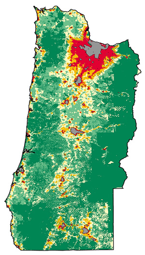
building density thresholds. The projections are displayed
as GIS maps and will be used to inform other CLAMS models
describing forest management and habitat suitability. The
research describes the future social context in which forestry
in the CLAMS region will operate.
- Posters
|
Projected Development on Forested Lands
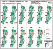
PDF - 3.2 mb
|
- Publications
Kline, J. D., D. L. Azuma, and A. Moses. In Press.
Modeling the Spatial Dynamic Distribution of Humans on a
Landscape. Landscape Ecology.
Kline, J. D., A. Moses, and R. J. Alig. 2001. Integrating
Urbanization into Landscape-level Ecological Assessments.
Ecosystems, 4(1):3-18.
|