Road network coverage was built in the following general steps.
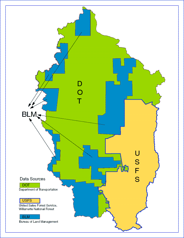
Figure 1: Polygon Boundaries of data Sources used to
build Willamette Road Network
BLM Coverages
Layer name: blm024trb.e00
Contacts: Lisa Blackburn
Telephone: (503) 952-6276
Mail: Bureau of Land Management
Oregon State Office
ATTN: Lisa Blackburn
PO Box 2965
Portland, OR 97208
To Visit: Bureau of Land Management
Oregon State Office 7th Floor
1515 SW 5th Ave
Portland, OR 97201
We received a tape from a contractor with the BLM; the
tape came with no meta-data.
The data-set consisted of a tar file (blm024e00.tar)
containing ARC/INFO export files.
These Files were imported into ARC/INFO; appended and
re-projected using a UTM,
zone 10 projection.
When imported the files had the form axxxxxtrb.e00 or
axxxxxxrb.e00 (x indicating
coordinate locations of the coverages); xrb indicating
that the coverages were
outside the boundaries of the BLM; trb indicating that
the coverages were inside the
BLM boundaries. We used the data that fell under the
jurisdiction of the BLM, the trb
set.
ODOT Coverages:
Layer name: dot97c
dot97c was built using data-sets downloaded from ODOT's
ftp site:
ftp://ftp.odot.state.or.us/tdb/trandata/maps.
The sets were formatted in .LAM (Intergraph) format (i.e.BAKE1.LAM,BAKE2.LAM,
etc).
Once the 13 counties intersecting the WRB had been downloaded;
they were imported
into ARC/INFO using the ARC/INFO IGDSARC command.
National Forests Coverages
Willamette National Forest
Layer name: tran96.e00
Contacts: Rosanna Costello (541)344-2263
Metadata for this coverage was provided in analog form
by Kate Kirsh (541)346-4870
in a draft document entitled: Mini Data Dictionary -
Willamette National Forest; a
transcript of this document follows: GIS layer name:
transportation; GIS layer file
name: tran96 ;GIS data type: line; date: june 26, 1996
Mt. Hood National Forest
Layer name: THMSMTH97.
Rich Haguestadt.
Umpqua National Forest
Layer name: CGROADS
Contact: Kate Kirsh (541)346-4870.
Coverages from DOT, BLM and USFS data overlap. In addition,
the schema of their databases
have different columns rows and item definitions. Also,
they were built for different purposes.
For RDNET, the road network that had the most linear features,
was deemed to be the most
accurate. The portion that was deemed to be the most
accurate was fitted with polygon
boundaries. These polygon boundaries were joined with
the line coverage (road network of
each data source). This procedure generated geographically
exclusive road coverages. One
polygon boundary for each road network of each source.
All these polygons were then joined
to each other to form coverage with all attributes of
the exclusive data-sets.
Note: only line-work is valid; attributes of individual coverages were not presserved.