 Yoshkar Ola
56,370 N, 47° 53′ 45″ E
Yoshkar Ola
56,370 N, 47° 53′ 45″ E
Russian Federation, Povolzhye Region: southern part of Republic Mari-El, northern part of Republic Chuvashia, eastern part of Republic Tatarstan, and small south-eastern part of Nizhniy Novgorod oblast.
Site Investigators
- Eldar Kurbanov, Yoshkar Ola, Mari State Technical University, Mari El Republic, Russia
Site Description
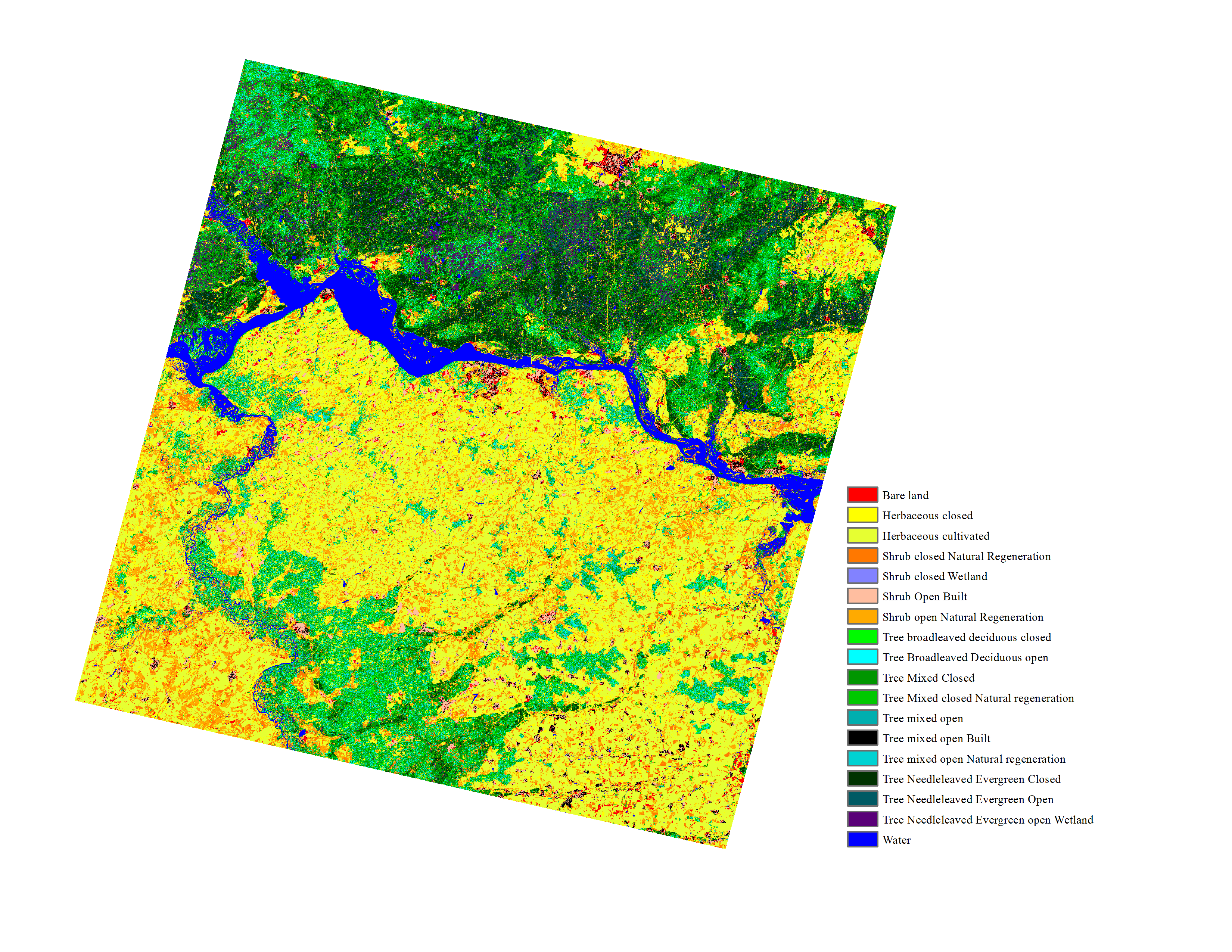
The site is located in the Eastern part of the Russian plain between 55-60° N and 44-52° E where it occupies 23,200 km2. The territory is a hilly plain with elevation range from 45 to 275 m above the sea level. The climate is moderately-continental with distinct and stable weather in winter and summer and variable weather in spring and fall. The mean annual temperature varies from +2.20 C in the north-eastern part to +3.10 C in the south-west. In recent years, winter months have been warmer than they used to be. The average amount of precipitation is 450-500 mm, including 200-250 mm during vegetation period.
The region can be subdivided into three ecological zones: southern taiga, mixed forest and forest-steppe. The Volga River serves as the natural western border of physiographic and natural conditions. The northern part (Kirovskaya oblast) belongs to the taiga zone. Along the Volga River the central lowland extends as a wide band with a great number of lakes, marshes and rivers. The high right bank elevates above the valley of the Volga River in the form of a steep ledge with deep ravines and gullies. The forest cover ranges between 16% in the SE to 57 % in the NW and the dominant species include pine (Pinus sylvestris L.), birch (Betula pendula Roth. and
Betula pubescens Ehrh.), spruce (Picea abies Karst. and
Picea obovata Ledeb.), and aspen (Populus tremula L.). Forests of low (left) bank of the Volga river are dominated by pine on sandy soils and mixed stands of birch, lime (Tilia spp), and aspen on more productive soils. Forests on the high (right) bank are dominated by broad-leaved hardwoods including oak (Quercus robur), lime, maple (Acer platanoides), elm (Ulmus spp.), and ash (Fraxinus excelsior). The second most important type of landcover are cereal crops; there are also pastures in the flood plain; peatlands dispersed all over the region; ravines; young forest plantations.
Land Cover

Click for larger image
Land Cover Change (Preliminary)

Click for larger image
Download
- Land Cover (preview - png) (data - 1.3 MB, geoTiff.zip)
Global Map Analysis
Comparison of dominant life form types
-->Publications
- Kurbanov, E.A. (2010): Application of ALOS satellite images for the identification of reforestation on abandoned agricultural lands / E. Kurbanov, O. Vorobiev, A. Gubayev, S. Leznin // Geomatica. – Moscow. Sovzond. - № 4. – p. 68-72.
- Kurbanov, E.A. (2007). Carbon sequestration after pine afforestation on marginal lands in the Povolgie region of Russia: A case study of the potential for a Joint Implementation activity // E. Kurbanov, O. Vorobiev, A. Gubayev, L. Moshkina, S. Leznin // Scandinavian Journal of Forest Research. - № 22: 488-499.
- Kurbanov, E.А. (2007): Estimation of pine plantations phytomass of Mari Zavolzhye by satellite images of Landsat -7 (ETM+) /E.А. Kurbanov, О.N. Vorobyov, L.S. Moshkina, А.V. Gubaev, С.А. Lezhnin // Conference proceedings 8th International conference on Pattern recognition and image analyses: new information technologies. Yoshkar-Ola, Vol. 2, p. 295-297.