 Mongolia
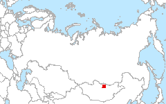
46-48°N 105-108°E
Site Investigators
- Dr. Tsolmon Renchin - NUM-ITC-UNESCO Remote Sensing/GIS Laboratory, The National University of Mongolia, Ulaanbaatar, Mongolia
Site Description
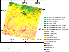
The study area is located in central Mongolia; it is centered on Tuv province and includes the capital city of Ulaanbaatar. The land surface is composed of three broad vegetation types: forest steppe, steppe, and desert-steppe. The forest steppe zone stretches from the lower slopes of the Khentii Mountains to the steppe zone with elevation of 850-1400 m above sea level. Average annual precipitation is 300-400 mm; spring and autumn periods are dry. The frost-free growing season lasts 112-125 days. Carbonated and non-carbonated fine black-brown soil is widespread in this zone. Primary tree species include the Siberian Larch (Larix siberica), Siberian Pine (Pinus sibirica), birch (Betula spp.) and poplar (Populus laurifolia). The Mongolian steppe is different from other steppe zones in that it is dominated by low shrubs and semi-shrubs such as Caragana spp. and Artemisia spp. Fertile carbonated and non-carbonated black and sandy soils prevail in this zone. Saline soil is found along depressions and channels of seasonal streams. Mean annual precipitation is 125-250 mm. The desert steppe is located between the Mongolian steppe and Central Asian desert. Brown soils prevail and largely determine the appearance of desert-steppe zone as vegetation is sparse. Salt marshes are common. Mean annual precipitation is 100-125 mm; non-irrigated areas are not suitable for cultivation.
Mongolia has undergone an economic and political transition into a market economy since the 1990s and has suffered great economic hardship. Socio-economic factors such as poverty and profit-seeking have greatly increased small and large scale mining activities. This contributed to the loss of biodiversity, increased land degradationand increased social vulnerability. The expansion of manual mining in Tuv province also resulted in increased soil erosion and land degradation. Some parts of the study areas are undergoing vegetation rehabilitation after mining where mine tailings are covered with topsoil and vegetation is planted. The loss of regional economic activities has caused migration from the rural areas into urban centers leading to a major decrease of cropland areas, increased pasture degradation, reduced surface and ground water, and increased water pollution. Ongoing desertification has lead to droughts and dust storms.
Download
- Site Report (0.0 MB - PDF)
- Land Cover (preview - 597 kB,png) (data - 4.5 MB, geoTiff.zip)
- Source Landsat imagery available via LARSE Image Database
Global Map Analysis

