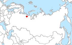
 Komi
66.95°N 55.62°E
Komi
66.95°N 55.62°E
Russian Federation, North-east part of European Russia, North part of Komi Republic (KR) and Nenets Autonomous District (NAD). Main natural landscapes related with taiga-tundra ecotone zone.
Investigators
- Vladimir Elsakov, Institute of Biology, Russian Academy of Sciences
Site Description
The site located in North part of Pechora river basin. Almost one fourth of that area is located close and behind the Polar circle. It determines all natural features of components of natural ecosystems. For the most area of these landscapes the radiating balance is near 20-25 kcal/cm2. For compare the most north delta Pechora part near 15-20 kcal/cm2 per year (Atlas of Arctic, 1985). Severe climate (the period of days with average temperature higher than 10°C is about 40 days per year), superfluous humidity (the annual precipitation volume decreases from south to north from 500 to 360 mm), in combination with relatively flat relief and seasonally-frozen ground (permafrost), determine the high degree of water saturation and presence of many wetlands. Current development of vegetation cover of territory depends on a complex of local physical and geographical conditions and the region’s history establishment. Almost all ecosystems are characterized by a small phytomass value and capacity of biogeochemical cycling of biological elements, development of cryogenic processes. At the same time, despite rather its poor species composition the vegetation-soil cover of tundra and forest-tundra communities is remarkable by high diversity and microrelief dependent complexes. Low heat provision and superfluous humidity on the significant part of territory account for slow mineralization processes of soil organic matter and, as consequence peat accumulation and gleyzation. As result, weakly peaty and peaty-glay soils also boggy soils are formed were peat are respected by different decomposition forms. 3 Biodiversity formation of a flora and fauna began relatively recently (as evidence - absence of endemic and relicts species) and relates to the time of Pliocene-Pleistocene. In most cases fauna and flora formation depended on change of temperature conditions of territory and sea transgressions. Vegetation cover of today’s communities was formed also under influence of reindeer grazing during last millenniums. More than 20 reindeer-breeding farms exist in region.
Land Cover

Click for larger image
Download
- Site Report (1.4 MB - PDF)
- Land Cover (preview; data - 12.1MB, geoTiff.zip)
- Source Landsat imagery available via LARSE Image Database
Global Map Analysis
Comparison of dominant life form types
Publications
- Elsakov V.V. 2005 Remote sensing monitoring of plant cover disturbances in oil deposits. Modern problems of Remote sensing Earth from Space. Articles of conference. Moscow, Institute of Space research, 2005. Pp. 152-155. Formatted: English (U.S.)15
- Elsakov V.V., Taskaev A.I. Geoinformation technology in fundamental and applied investigation of ecosystems of Timan-Pechora oil-gas province // Article of VIII Scientific conference of thematically mapping: «Geoinformation mapping for balanced territorial development». Novosibirsk, 2006. Pp. 128-129.
- Elsakov V.V. 2007 Satellite monitoring in investigation of spatial and temporal changes of phytosystems of European tundra communities. Articles of international conference: Modern plant physiology: from molecules to ecosystems. Part 3. Syktyvkar, 2007. Pp.27-28.
- Elsakov V.V., Deneva S.V. Estimation of spatial distribution of polluting substanses in technogenic landscapes of Srednecharjaginskoe oil field: Modern problems of soil pollution. V2. Moscow, 2007. Pp. 52-55.
- Elsakov V.V. Satellite monitoring in ecological research of Komi Republic oil deposits: Articles of IV scientific conference « Return aims and information technology of rational nature management. Chanty-Mansiisk, 2008. Pp. 164-167.