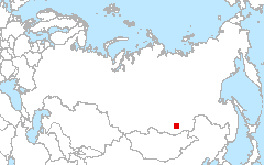
 Chita
57.12°N 111.10°E
Chita
57.12°N 111.10°E
Russian Federation, on the borderline between the Republic of Buriatia and Chitinskaya Oblast.
Site Investigators
- Tatiana Loboda, University of Maryland
Site Description
The site is found in the southern part of Eastern Siberia to the east of Lake Baikal. The site spans across several chains of the Zabaikalye Mountain system around Yablonovy Mountain Range with the elevations ranging between 600 and 1500 m and individual peaks reaching 1681 m (Kusotuy Mountain). The region’s ecosystems developed cold climatic conditions with mean annual temperature of -4°C and mean January temperatures around -26°C and mean July temperatures around 15°C (Stolbovoi and McCallum, 2003). Despite the position of the site deeply within the Siberian continent the test site receives ~ 380 mm of rainfall per year with the major peak during summer months. The area experiences roughly between 95 and 120 frost-free days per year depending on the elevation of the area above sea level. The duration of vegetative periods becomes shorter with the increase in the altitude. However, the exact number of frost-free days is also determined by the exposition of the slopes and relief configuration. Mountain valleys of the study site host five major river including Uda, Khudan, Khilok, Olenguy, and Ingoda and multiple lakes of difference sizes. The ecosystems of this test site developed within the zone of discontinuous permafrost (50-90% permafrost extent) and ice thickness of less than 20 cm (Stolbovoi and McCann, 2003). Despite the wide spread of permafrost within the site ~ 50% of the soils are well drained, 23% are moderately-well drained, 7% are moderately-poorly drained, 14% are poorly drained and 6% are excessively drained (based on soil properties data in Stolbovoi and McCann, 2003). The poorly drained soils of the Khilok river valley frequently correspond to swamped areas with shallow (30-50cm) peat accumulation. On average soil carbon density of the top 30 cm of the soil is ~64 C kg/m2. The site represents predominantly tree-dominated landscapes with larch, pine and birch among the dominate tree species. The northern part of the test site includes extensive shrub dominated communities covered with dwarf birch. River valleys are largely non-forested.
Land Cover

Click for larger image
Land Cover Change

Click for larger image
Download
- Site Report (1.9 MB - PDF)
- Land Cover (preview - 859kB,png) (data - 8.4MB, geoTiff.zip)
- Land Cover Change (preview - 782kB,png) (data - 5.7MB, geoTiff.zip)
- Source Landsat imagery available via LARSE Image Database
Global Map Analysis