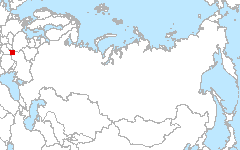
 Carpathians
49.08°N 22.73°E
Carpathians
49.08°N 22.73°E
The Carpathian test site extends across four European countries: Poland (Podkarpatie Voivodship), Slovakia (Presovsky and Kosicky Kraj), Ukraine (Zakarpatska and Lvivska Oblast), and Hungary (Szabolcs-Szatmar-Bereg and Borsod-Abaúj-Zemplén Counties).
Investigators
- Tobias Kuemmerle, Humboldt-University of Berlin (currently at University of Wisconsin-Madison)
Site Description
The site is located in the border region of Poland, Slovakia, Ukraine, and Hungary. Most of the region is part of the Carpathian Mountain range and is characterized by mountainous terrain. The center of the site’s south is characterized by flat terrain and is part of the Pannonian Plain. Besides the Carpathain Mountain range, major geographical features of the site include the rivers of Borzera, Dnister, Laborec, Latorycja, Ondava, San, and Uzh, as well as the Solina, Sirava, and Ondava water reservoirs. Altitudes vary from 100m to above 1400m above sea level. The bedrock is largely dominated by sandstone and shale, but some andesite-basalts occur in the southwest of the study area. Dominating soils include cambisols and podzols in the mountainous regions; podzoluvisols, greysems, and gleysols in the plains; and fluvisols in alluvial plains. Climate in the region is moderately cool and humid with marked continental influence. Average annual precipitation amounts to 1100-1200 mm, mean annual temperature is 5.9°C (at 300m), and the growing season ranges from >270 days below 500m altitude to < 220 days above 800 m. Potential natural vegetation of the region occurs in three altitudinal zones. The foothills (< 600m) are mostly covered by broadleaved forests, consisting of European beech (Fagus sylvatica), pedunculate oak (Quercus robur), sessile oak (Quercus petraea), lime (Tilia cordata), and hornbeam (Carpinus betulus). The montane zone (600-1,100 m) is dominated by European beech (Fagus sylvatica), mixed with silver fir (Abies alba), Norway spruce (Picea abies), European maple (Acer pseudoplatanus), and white alder (Alnus incana). The timberline of dwarfed beech (1100-1200m) directly borders alpine meadows on hilltops.
Land Cover

Click for larger image
Land Cover Change

Click for larger image
Download
- Site Report (1.1 MB - PDF)
- Land Cover (preview; data - 6.4MB, geoTiff.zip)
- Land Cover Change (preview; data - 290MB, geoTiff.zip)
- Source Landsat imagery available via LARSE Image Database
Global Map Analysis
Comparison of dominant life form types
Publications
- Kuemmerle, T., Kozak, J., Radeloff, V.C., and Hostert, P. (2008): Differences in forest disturbance rates among land ownership types in Poland during and after socialism. Journal of Land Use Science, forthcoming.
- Kuemmerle, T., Hostert, P., St-Louis, V., and Radeloff, V.C. (2008): Using image texture to map field size in Eastern Europe. Journal of Land Use Science, forthcoming.
- Kuemmerle, T., Hostert, P., Radeloff, V.C., Perzanowski, K, and Kruhlov, I. (2008): Postsocialist farmland abandonment in the Carpathians. Ecosystems, 11, 614-628.
- Kuemmerle, T. and Damm, A. (2008): A method to detect and correct single-band missing pixels in Landsat TM and ETM+ data. Computers and Geosciences, 34, 445-455.
- Kuemmerle, T., Hostert, P., Radeloff, V.C., Perzanowski, K, and Kruhlov, I. (2007): Postsocialist forest disturbance in the Carpathian border region of Poland, Slovakia, and Ukraine, Ecological Applications, 15, 1279-1295.
- Kuemmerle, T., Radeloff, V.C., Perzanowski, K, and Hostert, P. (2006): Cross-border comparison of land cover and landscape pattern in Eastern Europe using a hybrid classification technique. Remote Sensing of Environment, 103, 449-464.