Estimation of disturbance map accuracy
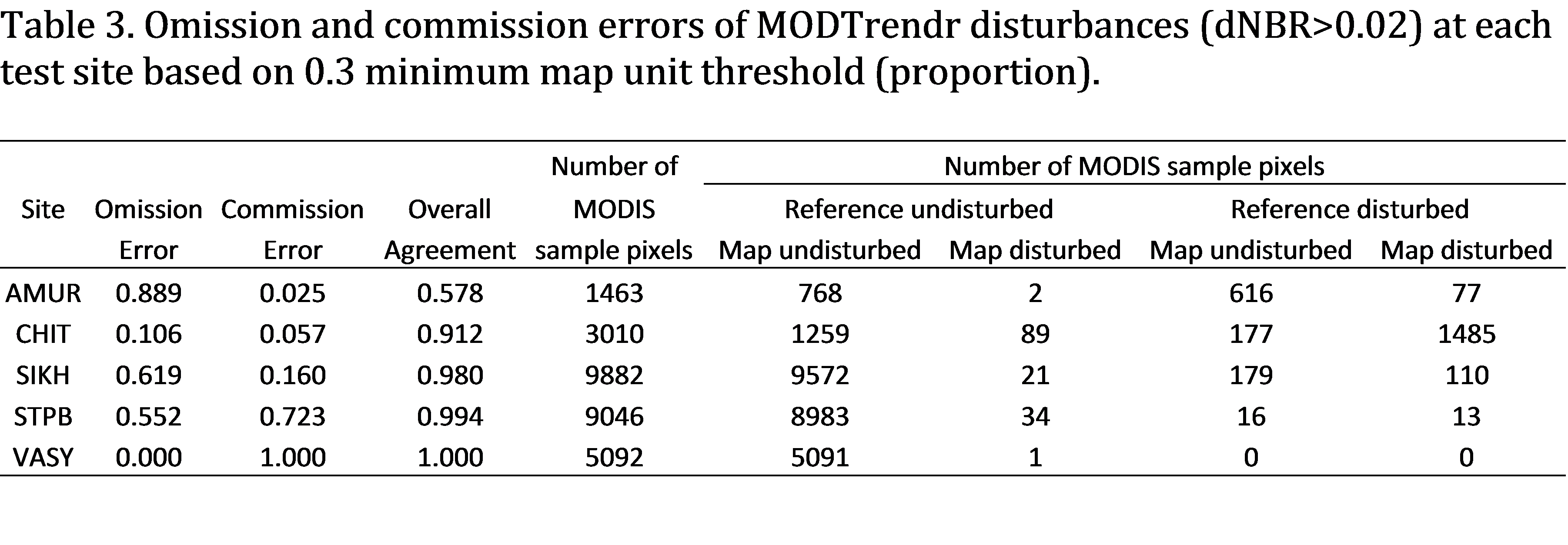
Two measures of map accuracy were used: error of omission (falsely excluding disturbances) and error of commission (falsely including disturbances). At each test site, a temporal filter was applied to the MODTrendr outputs, such that only disturbances that started within the Landsat-based mapping period were included in the assessment. MODIS pixels where disturbance started before or after the Landsat-based mapping period were relabeled as undisturbed.
Following the NELDA protocols for assessing accuracy of coarse resolution maps ( Pflugmacher et al., 2011), we estimated omission and commission errors based on sub-pixel fractional agreement between the MODTrendr and Landsat disturbance maps. The reference class (from Landsat) is continuous and includes disturbed area proportions between 0.05 and 1.0 and the map class (from MODTrendr) is categorical (disturbed and undisturbed). Fractional errors are then estimated based on the differences in the disturbed area proportions between MODIS and Landsat.

To compare the MODTrendr performance with the study from Sulla-Menashe et al. (2014), we also estimated commission and omission errors using a categorical reference class scheme. Here, the Landsat disturbed area proportions were converted to binary disturbance maps based on a minimum proportion threshold. As in Sulla-Menashe et al. (2014), we used three thresholds: 0.05, 0.30, and 0.70 to produce three categorical reference maps at the MODIS resolution. Increasing the minimum proportion threshold effectively increases the minimum map unit of the Landsat disturbance map. Hence, in the following we also refer to the minimum proportion threshold as minimum map unit proportions.

References
- Pflugmacher, D., Krankina, O., Cohen, W.B., Friedl, M.A., Sulla-Menashe, D., Kennedy, R.E., Nelson, P., Loboda, T.V., Kuemmerle, T., Dyukarev, E., Elsakov, V., & Kharuk, V.I. (2011). Comparison and assessment of coarse resolution land cover maps for Northern Eurasia. Remote Sensing of Environment, 115, 3539-3553.
- Sulla-Menashe, D., Kennedy, R.E., Yang, Z., Braaten, J., Krankina, O.N., & Friedl, M.A. 2014. Detecting forest disturbance in the Pacific Northwest from MODIS time series using temporal segmentation. Remote Sensing of Environment (in press). Available online 7 November 2013, ISSN 0034-4257, URL
Credit:
- D. Pflugmacher, D. Sulla-Menashe, O. Krankina. “ASSESSMENT OF THE MODTRENDR ALGORITHM FOR MAPPING FOREST DISTURBANCES IN NORTHERN EURASIA” NELDA-II REPORT (UNPUBLISHED)
