Erosion
was large on burned soil relative to unburned
soil, at least at small scales. Evidence indicating large short-distance transport included controlled erosion boxes and pins. Boxes showed a relation for burned soil between slope and transport, as expected.
Pins demonstrated fluctuating
soil-surface heights (relative to the top of rebar grid-point posts). We failed to see, however, significant movement at the base of hotly burned units. Little soil accumulated in ditches above the road.
Microtopography from old windthrow
mounds, stumps, and decaying logs appeared
to sharply limit long-distance transport.
Needles that fell from heat-killed conifers formed numerous needle dams in the first and second year after the fire, trapping large amounts of ash. Needles
appeared to decompose by the 3rd year and ash may be moving again, so any nutrient or soil trapping effects may not differ from initially treeless areas over time.
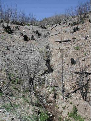
The photo on the left is the
intermittent stream at the
base of the 30-acre hotly burned LTEP pioneer treatments.
Little soil accumulated in the ditch along the road where this photo was taken.
Objectives
related to this finding
Methods
related to this finding
related to this finding
Initial results and graphs
related to this finding
related to this finding

Rain-driven
erosion was large but local.

Initial Findings
Finding 8

HOME