B9 evidence
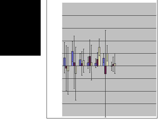
Erosion based on erosion-pin data across LTEP stands
Erosion measured as changes in elevations of the soil relative to the top of grid-point rebar posts. Net gains are positive and losses are negative with 95% confidence intervals.
-2.0
-1.5
-1.0
-0.5
0.0
0.5
1.0
1.5
2.0


Oct. to Dec., 2002
Dec. to Jan., 2003
Jan. to Feb., 2003


Wildfire-burned stands

Backburn

Ground elevation increased by 1 to 8 mm on plots from October to December, 2002 following the fire (but only a few intervals do not include zero).
After December 2002, elevation trends are negative in 3, mixed in 6, and positive in 3 stands.
Volatility of gains and losses suggest local soil movement was wide-spread right after the fire.
Initial results:
HOME